


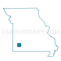
Mt. Pleasant Voting District, Lawrence County, Missouri
About
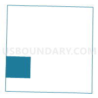
Outline

Summary
| Unique Area Identifier | 608945 |
| Name | Mt. Pleasant Voting District |
| County | Lawrence County |
| State | Missouri |
| Area (square miles) | 42.08 |
| Land Area (square miles) | 42.01 |
| Water Area (square miles) | 0.07 |
| % of Land Area | 99.84 |
| % of Water Area | 0.16 |
| Latitude of the Internal Point | 37.02832100 |
| Longtitude of the Internal Point | -93.99779340 |
Maps

Graphs
Select a template below for downloading or customizing gragh for Mt. Pleasant Voting District, Lawrence County, Missouri


Neighbors
Neighoring Voting District (by Name) Neighboring Voting District on the Map
- Forest Park Voting District, Lawrence County, MO
- Freistatt Voting District, Lawrence County, MO
- Hoberg Voting District, Lawrence County, MO
- Pierce City Voting District, Lawrence County, MO
- SARCOXIE 1 AND 2 Voting District, Jasper County, MO
- Vineyard Voting District, Lawrence County, MO
- Wentworth Voting District, Newton County, MO
Top 10 Neighboring County Subdivision (by Population) Neighboring County Subdivision on the Map
- Pierce township, Lawrence County, MO (6,586)
- Sarcoxie township, Jasper County, MO (3,043)
- Van Buren township, Newton County, MO (1,374)
- Vineyard township, Lawrence County, MO (1,048)
- Mount Pleasant township, Lawrence County, MO (922)
- Hoberg township, Lawrence County, MO (706)
- Freistatt township, Lawrence County, MO (549)
Top 10 Neighboring Unified School District (by Population) Neighboring Unified School District on the Map
- Monett R-I School District, MO (12,231)
- Mount Vernon R-V School District, MO (9,214)
- Pierce City R-VI School District, MO (4,344)
- Sarcoxie R-II School District, MO (4,107)
Top 10 Neighboring State Legislative District Lower Chamber (by Population) Neighboring State Legislative District Lower Chamber on the Map
- State House District 132, MO (37,081)
- State House District 126, MO (36,895)
- State House District 131, MO (36,451)
Top 10 Neighboring State Legislative District Upper Chamber (by Population) Neighboring State Legislative District Upper Chamber on the Map
Top 10 Neighboring 111th Congressional District (by Population) Neighboring 111th Congressional District on the Map
Top 10 Neighboring Census Tract (by Population) Neighboring Census Tract on the Map
- Census Tract 204, Newton County, MO (7,401)
- Census Tract 4704, Lawrence County, MO (6,665)
- Census Tract 4703, Lawrence County, MO (5,445)
- Census Tract 120, Jasper County, MO (5,417)
Top 10 Neighboring 5-Digit ZIP Code Tabulation Area (by Population) Neighboring 5-Digit ZIP Code Tabulation Area on the Map
- 65708, MO (12,624)
- 65712, MO (8,494)
- 65723, MO (3,606)
- 64862, MO (3,337)
- 64873, MO (1,072)
- 65756, MO (748)